
Location and Travel Details
School of Engineering and Materials Science
Queen Mary University of London
Mile End Road
London E1 4NS
UK
 given.racing.living
QMUL London Sites
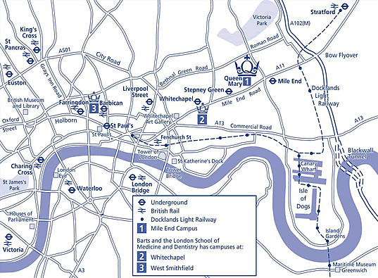
QMUL Mile End Campus
Travel
Underground
| Bakerloo | Good Service |
| Central | Minor Delays |
| Circle | Good Service |
| District | Good Service |
| DLR | Good Service |
| Elizabeth line | Good Service |
| Hammersmith & City | Good Service |
| Jubilee | Good Service |
| Liberty | Good Service |
| Lioness | Good Service |
| Metropolitan | Good Service |
| Mildmay | Good Service |
| Northern | Good Service |
| Piccadilly | Part Closure |
| Suffragette | Good Service |
| Victoria | Good Service |
| Waterloo & City | Good Service |
| Weaver | Good Service |
| Windrush | Good Service |
The College is within a five minute walk of both Mile End station (Central, District, and Hammersmith & City lines) and Stepney Green station (District, and Hammersmith & City lines).
Mile End station is east of the College on the opposite side of the Mile End Road. Turn left out of the station and cross Burdett Road and Mile End Road at the traffic lights, continue along Mile End Road until you reach the College buildings on the right.
Stepney Green station is to the west of the College. Turn left out of the station, cross Globe Road and continue along Mile End Road.
The East London line runs from south of the Thames (New Cross station) and terminates at Whitechapel station, where there is a connection to Stepney Green and Mile End stations.
Buses
The 25 (Oxford Circus to Ilford) and 205 (Paddington to Bow Church) buses travel along Mile End Road and stop outside the College. The following buses stop near Mile End Underground station, within five minutes' walk of the College: 277 (Highbury & Islington to the Isle of Dogs via Canary Wharf), D6 (Isle of Dogs via Mile End to Hackney Central), D7 (Poplar to Mile End tube station via the Isle of Dogs and Canary Wharf). In addition, the 309 (Poplar to Bethnal Green) stops outside Stepney Green tube station.
Two night buses stop at Mile End on route: N76 (Trafalgar Square to Hainault) and N25 (Victoria/Trafalgar Square to Harold Wood).
Docklands Light Railway (DLR)
The DLR runs from Bank and Tower Gateway stations in the City to the Isle of Dogs, the London docks and Stratford. The nearest stations to College are Bow Church and Limehouse, both about three-quarters of a mile from the Mile End campus.
Airports
The College is easily reached from London's main international airports at Heathrow, Gatwick and Stansted. London City Airport with regular continental flights is five miles to the east of the College.
By Car
Please note - there is no parking on Campus. The streets around the campus offer metered parking. Street parking is generally free from 17:30 Monday to Friday, and free all weekend - but check the local signage.
From the east and north: Get onto the M25 and head towards junction 27 with the M11. On the M11 head south until you reach junction 4. Follow the signs for the City and the A12 and then head west along the A12, leaving at the exit for the A11, signposted Stratford and Bow. Take the A11 exit signed for the City. As you near Mile End and the College you will see Mile End underground station on your left. Go straight through the next set of traffic lights and the College is another four hundred metres on the right.
From the west: Get onto the M40 and follow it through west London on the A40 and A40(M). Once on the A40(M) Westway flyover follow the signs for the City and the A501 (City Ring Road). Once on the A501 follow it through Euston, King's Cross and Pentonville until you reach Old Street roundabout (distinguished by the two large arches in the middle of it) and take the first exit along the A5201 (East). Travel for a third of a mile and then turn right onto the A10 (South). After about a third of a mile follow the signs left for the A1202 (Commercial Street). After about half a mile turn left onto the A11 (East). Drive through Aldgate East and Whitechapel until you see Stepney Green underground station on your left. The College is then another four hundred metres on the left.
From the south-west: Get on to the M3 and head towards London. Keep following the M3 as it changes into the A316. Follow the A316 through south-west London until you reach the Chiswick roundabout, at which you should change onto the A4. Follow the A4 through Hammersmith and then in Earls Court turn right onto the A3220. This will lead you to Embankment (A3212). Follow the Embankment through Westminster and the City until you reach the Tower of London and then follow signs for the A11 and Aldgate East. Once on the A11 head east following signs for Whitechapel and Mile End. After about a mile you will see Stepney Green underground station on your left. The College is another four metres on the left-hand side of the road.
From the south: Get on to the A205 (South Circular Road) and follow the signs for the A2. Once on the A2 head north following signs for the A102(M) and Blackwall Tunnel. Go on the A102 (North) and through the Blackwall Tunnel. Once through the Tunnel continue north for another mile and a half until you reach the A11. Head west along the A11 through Bow. As you near Mile End and the College you will see Mile End underground station on your left. Go straight through the next set of traffic lights and the College is another four hundred metres on the right.
By Bicycle Hire
Details on London's bicycle hire scheme (colloquially called "Boris Bikes") can be found on Transport for London's website. There is a bicycle hire docking station opposite the Engineering Building and three to four other stations within a short walk of the campus.